Issued on Saturday 4th April, 2026 at 18:00
Vanuatu Standard Time
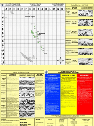
Information Number 1 on a Tropical Low
At 5:00pm local time today, Tropical Low (TL) (1000 hPa) was located at 13.0S 171.1E. The Tropical Low is positioned at the bottom left corner of square letter L, number 3 (L, 3) of the Vanuatu tropical cyclone tracking map. That is about 420 KM east northeast of the Banks group. The system is slow moving in the southerly direction at 23 KM/HR. The potential for the tropical low to become a tropical cyclone within the next 24 hours is low to moderate. Forecast Positions Date and Time Position Intensity +06 hours (11pm, 4 Apr) 13.4S, 170.9E 25 KTS (45 KM/HR) +12 hours (5am, 5 Apr) 13.7S, 170.8E 25 KTS (45 KM/HR) +18 hours (11am, 5 Apr) 14.0S, 170.7E 25 KTS (45 KM/HR) +24 hours (5pm, 5 Apr) 14.2S, 170.9E 25 KTS (45 KM/HR) +36 hours (5am, 6 Apr) 14.6S, 171.3E 30 KTS (55 KM/HR) +48 hours (5pm, 6 Apr) 15.2S, 171.7E 40 KTS (75 KM/HR) +60 hours (5am, 7 Apr) 16.0S, 172.1E 40 KTS (75 KM/HR) +72 hours (5pm, 7 Apr) 17.0S, 172.7E 40 KTS (75 KM/HR) Currently this low pressure system does not pose any threat to any island of Vanuatu. Heavy rainfall and gustily winds is expected over northern islands as the system tracks closer to northern Vanuatu group in the next 48 hours. A strong wind warning is current for all open coastal waters of Vanuatu group. See Separate Marine Warning Bulletin. The next information on the system will be issued at 6:00am tomorrow or earlier if the situation changes. This information is also available on the VMGD: websit: www.vmgd.gov.vu, facebook: https://www.facebook.com/vmgd.gov.vu/ -------------------------- Bislama Version -------------------------- Infomesen Namba 1 long Tropikol Tropikol Lo (TL) we i kamaot long Vanuatu Meteorology mo Geo-hazards Department, Port Vila long 6:00pm VUT Saturday 4 April 2026. Long 5:00pm lokol taem tedei, Tropikol Lo (1000 hPa) hemi stap long 13.0S 171.1E. Tropikol Lo (TL) i stap lo senta blong skwea leta L, namba 3 (L, 3) long Vanuatu tropikol saeklon traking map. Hemia hemi samples 420 KM east northeast blong Banks group. Lo presa i muv sloslo long southerly direksen lo 23 KM/HR. Janis blo Tropikol lo hemi kam wan tropikol Saeklon lo nekis 24 aoa hemi lo kasem moderet. Fokas Posisen Dei mo Taem Posisen Pawa +06 hours (11pm, 4 Apr) 13.4S, 170.9E 25 KTS (45 KM/HR) +12 hours (5am, 5 Apr) 13.7S, 170.8E 25 KTS (45 KM/HR) +18 hours (11am, 5 Apr) 14.0S, 170.7E 25 KTS (45 KM/HR) +24 hours (5pm, 5 Apr) 14.2S, 170.9E 25 KTS (45 KM/HR) +36 hours (5am, 6 Apr) 14.6S, 171.3E 30 KTS (55 KM/HR) +48 hours (5pm, 6 Apr) 15.2S, 171.7E 40 KTS (75 KM/HR) +72 hours (5pm, 7 Apr) 17.0S, 172.7E 40 KTS (75 KM/HR) +60 hours (5am, 7 Apr) 16.0S, 172.1E 40 KTS (75 KM/HR) +72 hours (5pm, 7 Apr) 17.0S, 172.7E 40 KTS (75 KM/HR) Naoia, lo presa sistem i no mekem denja iet long ol aelan blong Vanuatu. Be bae i save kat hevi ren i foldaon mo ol strong win we yumi save expektem lo noten aelans taem sistem ya hemi muv ikam kolosap lo noten grup blo Vanuatu lo nekis 48 aoa. I kat wan woning blong weta we e nogud tumas long saed long win aot saed long ol solwora blong Vanuatu. Yu save jekem lo seperet Marin Woning buletin. Niufala infomesen blong saeklon ia bae i kamaot long 6:00am tumoro o bifo long taem we i stap spos i kat jenis long rod blong saeklon. Infomesen ia i stap long websaet blong VMGD: www.vmgd.gov.vu mo long Facebook pej https://www.facebook.com/vmgd.gov.vu/
Legend
Community Threat
Warning Zone
Gales Within 24 Hours
Advisory Zone
Gales from 24 to 48 Hours
Past Cyclone Details
Past Location and Intensity Number
Past Track and Movement
Current Cyclone Details
Current location and intensity number
Very Destructive Winds
Destructive Winds
Gale Force Winds
Forecast Cyclone Details
up to 72 hours from time of issue
Forecast Location and Intensity Number
Very Destructive Wind Boundary
Destructive Wind Boundary
Gale Force Wind Boundary
Most Likely Future Track
Range of Likely Tracks
Tracking Map